
Crumbach topographic map
Interactive map
Click on the map to display elevation.
About this map
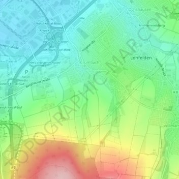
Name: Crumbach topographic map, elevation, terrain.
Location: Crumbach, Lohfelden, Landkreis Kassel, Hessen, Deutschland (51.25081 9.51312 51.28243 9.55090)
Average elevation: 220 m
Minimum elevation: 153 m
Maximum elevation: 350 m
Other topographic maps
Click on a map to view its topography, its elevation and its terrain.
Am Hammelsberg
Deutschland > Hessen > Landkreis Kassel > Lohfelden > Ochshausen
Am Hammelsberg, Ochshausen, Lohfelden, Landkreis Kassel, Hessen, 34253, Deutschland
Average elevation: 198 m
Vollmarshausen
Deutschland > Hessen > Landkreis Kassel > Lohfelden
Vollmarshausen, Lohfelden, Landkreis Kassel, Hessen, Deutschland
Average elevation: 251 m