
Talgar topographic map
Interactive map
Click on the map to display elevation.
About this map
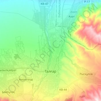
Name: Talgar topographic map, elevation, terrain.
Location: Talgar, Talgar District, Almaty Region, Kazakhstan (43.27599 77.19138 43.36656 77.26641)
Average elevation: 980 m
Minimum elevation: 771 m
Maximum elevation: 1,399 m
Talgar has a total area of 18.8 square km (7.3 mi²). The grade of the town's built-up areas is consistent with the natural unevenness of its overall natural geography. The average land elevation is 1250 m above sea level. The lowest points are in the northern part of the town at 1000 m, while the highest points at 1500 m are located in the town's south side.