Geolocate

Freckleton topographic map

Click on the map to display elevation.

About this map

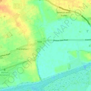
Name: Freckleton topographic map, elevation, terrain.

Location: Freckleton, Borough of Fylde, Lancashire, England, United Kingdom (53.73362 -2.88542 53.77774 -2.81986)

Average elevation: 12 m

Minimum elevation: 0 m

Maximum elevation: 32 m

Lancashire trails, hiking, mountain biking, running and outdoor activities

Other topographic maps

Click on a map to view its topography, its elevation and its terrain.

Weeton

United Kingdom > England > Lancashire > Borough of Fylde

Average elevation: 22 m

Clifton

United Kingdom > England > Lancashire > Borough of Fylde

Average elevation: 14 m

Warton

United Kingdom > England > Lancashire > Borough of Fylde

Average elevation: 12 m

Gear up for your next adventure:

🛰️Outdoor GPS Navigation - Navigation devices for remote and off-grid areas
🥾Hiking Boots - Waterproof and durable boots for long-distance hiking in the UK
📻Hand-Crank Emergency Radios - Stay updated on weather warnings in remote areas
🛰️Handheld GPS Devices - Reliable GPS units for hiking and outdoor navigation
🥼Base Layers - Thermal base layers for temperature regulation

As an Amazon Associate, this site earns from qualifying purchases at no extra cost to you.