
Mińsk County topographic map
Interactive map
Click on the map to display elevation.
About this map
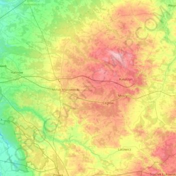
Name: Mińsk County topographic map, elevation, terrain.
Location: Mińsk County, Masovian Voivodeship, Poland (51.97357 21.23795 52.39501 21.97992)
Average elevation: 143 m
Minimum elevation: 87 m
Maximum elevation: 225 m
Other topographic maps
Click on a map to view its topography, its elevation and its terrain.
Mrozy
Poland > Masovian Voivodeship > Mińsk County
Mrozy, gmina Mrozy, Mińsk County, Masovian Voivodeship, Poland
Average elevation: 176 m