
West Des Moines topographic map
Interactive map
Click on the map to display elevation.
About this map
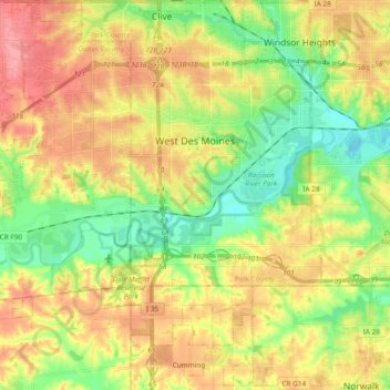
Name: West Des Moines topographic map, elevation, terrain.
Location: West Des Moines, Polk County, Iowa, United States (41.48927 -93.88687 41.60046 -93.69826)
Average elevation: 280 m
Minimum elevation: 238 m
Maximum elevation: 326 m
Other topographic maps
Click on a map to view its topography, its elevation and its terrain.
Des Moines
United States > Iowa > Polk County
Des Moines, Polk County, Iowa, United States
Average elevation: 264 m
Clive
United States > Iowa > Polk County
Clive, Polk County, Iowa, 50325, United States
Average elevation: 287 m
Ankeny
United States > Iowa > Polk County
Ankeny, Polk County, Iowa, United States
Average elevation: 283 m
Polk City
United States > Iowa > Polk County > Polk City > Polk City
Polk City, Polk County, Iowa, 50226, United States
Average elevation: 279 m
Des Moines
United States > Iowa > Polk County > Des Moines
Des Moines, Polk County, Iowa, 50319, United States
Average elevation: 271 m