
Make a donation
Gear up for your next adventure:
As an Amazon Associate, this site earns from qualifying purchases at no extra cost to you.
Tønsberg topographic map
Click on the map to display elevation.
Make a donation
Gear up for your next adventure:
As an Amazon Associate, this site earns from qualifying purchases at no extra cost to you.
About this map
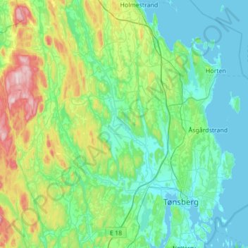
Name: Tønsberg topographic map, elevation, terrain.
Location: Tønsberg, Vestfold, Norway (59.22758 10.04261 59.48245 10.59080)
Average elevation: 83 m
Minimum elevation: -1 m
Maximum elevation: 415 m
Make a donation
Gear up for your next adventure:
As an Amazon Associate, this site earns from qualifying purchases at no extra cost to you.
Other topographic maps
Click on a map to view its topography, its elevation and its terrain.
Kodal
An ancient hill fort can be seen about 5 kilometres (3.1 mi) from the village centre of Kodal, connected by a hiking trail from the village centre. A closer parking lot can be found at Kodalveien 414. The trail is marked by blue paint on trees and rocks, and a variety of interpretive signs describing the fauna…
Average elevation: 75 m
Make a donation
Gear up for your next adventure:
As an Amazon Associate, this site earns from qualifying purchases at no extra cost to you.