
Vērgales pagasts topographic map
Interactive map
Click on the map to display elevation.
About this map
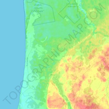
Name: Vērgales pagasts topographic map, elevation, terrain.
Average elevation: 15 m
Minimum elevation: 0 m
Maximum elevation: 54 m
Other topographic maps
Click on a map to view its topography, its elevation and its terrain.
Ploce
Latvia > Courland > Dienvidkurzemes novads > Vērgales pagasts
Ploce, Vērgales pagasts, Dienvidkurzemes novads, Courland, Latvia
Average elevation: 20 m