
Saguaro National Park topographic map
Interactive map
Click on the map to display elevation.
About this map
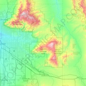
Name: Saguaro National Park topographic map, elevation, terrain.
Average elevation: 1,174 m
Minimum elevation: 699 m
Maximum elevation: 2,784 m
Other topographic maps
Click on a map to view its topography, its elevation and its terrain.
Tucson
États-Unis d'Amérique > Arizona > Pima County > Tucson
Tucson, Pima County, Arizona, 85701, États-Unis d'Amérique
Average elevation: 836 m