
Belle Plagne topographic map
Interactive map
Click on the map to display elevation.
About this map
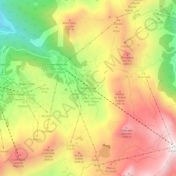
Name: Belle Plagne topographic map, elevation, terrain.
Average elevation: 2,204 m
Minimum elevation: 1,602 m
Maximum elevation: 2,722 m
Other topographic maps
Click on a map to view its topography, its elevation and its terrain.
Montchavin
France > Auvergne-Rhône-Alpes > Savoy > La Plagne-Tarentaise
Montchavin, Bellentre, La Plagne-Tarentaise, Albertville, Savoy, Auvergne-Rhône-Alpes, Metropolitan France, 73210, France
Average elevation: 1,196 m
Plagne Centre
France > Auvergne-Rhône-Alpes > Savoy > La Plagne-Tarentaise > Plagne Centre
Plagne Centre, Mâcot-la-Plagne, La Plagne-Tarentaise, Albertville, Savoy, Auvergne-Rhône-Alpes, Metropolitan France, 73210, France
Average elevation: 2,078 m