Geolocate

Lower Snug topographic map

Click on the map to display elevation.

About this map

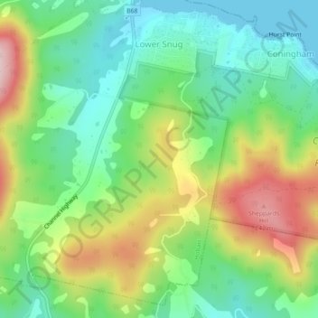
Name: Lower Snug topographic map, elevation, terrain.

Location: Lower Snug, Hobart, Kingborough, Tasmania, Australia (-43.10362 147.23096 -43.07137 147.26984)

Average elevation: 98 m

Minimum elevation: -1 m

Maximum elevation: 262 m

Other topographic maps

Click on a map to view its topography, its elevation and its terrain.

Selfs Point

Australia > Tasmania > Hobart

Average elevation: 17 m

Waterworks Reserve

Australia > Tasmania > Hobart

Average elevation: 240 m

James Austin Park

Australia > Tasmania > Hobart

Average elevation: 25 m

Perrins Ridge

Australia > Tasmania > Hobart

Average elevation: 467 m

Cartwright Point

Australia > Tasmania > Hobart

Average elevation: 59 m

Mount Direction

Australia > Tasmania > Hobart

Average elevation: 166 m

Glebe Hill

Australia > Tasmania > Hobart

Average elevation: 66 m

Knocklofty

Australia > Tasmania > Hobart

Average elevation: 185 m

Snug Falls

Australia > Tasmania > Hobart > Snug

Average elevation: 336 m

Tolosa Park

Australia > Tasmania > Hobart

Average elevation: 182 m

Glenrose Park

Australia > Tasmania > Hobart

Average elevation: 181 m

Gear up for your next adventure:

🔦Head Torches - Hands-free lighting for hiking and camping
🎒Multi-day Trekking Packs - Large capacity backpacks for wild camping and long-distance trails
🦟Anti-Midge & Tick Repellent - Vital for hiking in the Scottish Highlands during summer
🛌Sleeping Mats - Insulated mats for comfortable outdoor sleeping
🧺Ultralight Dry Bags - Organize and waterproof your gear inside your rucksack

As an Amazon Associate, this site earns from qualifying purchases at no extra cost to you.