
Velletri topographic map
Interactive map
Click on the map to display elevation.
About this map
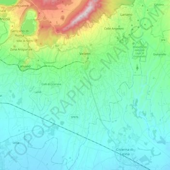
Name: Velletri topographic map, elevation, terrain.
Location: Velletri, Roma Capitale, Lazio, 00049, Italy (41.57274 12.69749 41.73926 12.84085)
Average elevation: 226 m
Minimum elevation: 51 m
Maximum elevation: 932 m
The old town's altitude is substantially uniform from the elevation of Piazza Giuseppe Garibaldi at 339 m above sea level, the square of the Trivium at 332 metres (1,089 feet) above sea level, and Napoletana at 329 metres (1,079 feet) above sea level. The area west of the walled city is a bit higher at San Lorenzo reaching 372 m (1,220 ft) above sea level. The remainder of the territory to the south and west is basically flat except for small hills that do not exceed 300 m (984 ft) above sea level.