
Le Locle topographic map
Interactive map
Click on the map to display elevation.
About this map
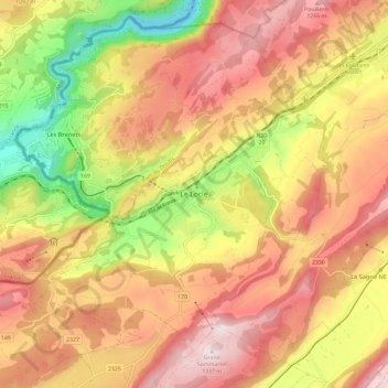
Name: Le Locle topographic map, elevation, terrain.
Location: Le Locle, Neuenburg, 2400, Schweiz (47.01559 6.70545 47.09559 6.78545)
Average elevation: 1,056 m
Minimum elevation: 697 m
Maximum elevation: 1,330 m
Le Locle liegt auf 920 m ü. M., 8 km südwestlich von La Chaux-de-Fonds (Luftlinie), nahe der Grenze zu Frankreich. Die Industriestadt erstreckt sich in einem engen, vom Bach Bied entwässerten Hochtal im Neuenburger Jura, zwischen den Höhen von Grand Som Martel im Süden und Pouillerel im Norden.