Geolocate

Monroe topographic map

Click on the map to display elevation.

About this map

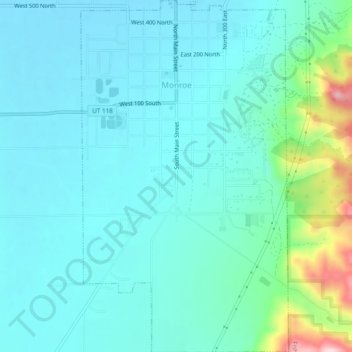
Name: Monroe topographic map, elevation, terrain.

Location: Monroe, Sevier County, Utah, 84754, United States (38.60360 -112.13442 38.64115 -112.10604)

Average elevation: 1,678 m

Minimum elevation: 1,626 m

Maximum elevation: 1,932 m

Other topographic maps

Click on a map to view its topography, its elevation and its terrain.

Monroe Peak

United States > Utah > Sevier County

Average elevation: 3,140 m

Sawtooth

United States > Utah > Sevier County

Average elevation: 2,069 m

Austin

United States > Utah > Sevier County

Average elevation: 1,624 m

Gear up for your next adventure:

🛌Insulated Sleeping Mats - Crucial thermal protection when sleeping on cold, uneven ground
🔦Head Torches - Hands-free lighting for hiking and camping
🦶Anti-Blister Balms - Protect your feet before long topographic expeditions
🥄Titanium Camping Sporks - The ultimate lightweight utensil for trail meals
🛰️Outdoor GPS Navigation - Navigation devices for remote and off-grid areas

As an Amazon Associate, this site earns from qualifying purchases at no extra cost to you.