
Kill Devil Hills topographic map
Interactive map
Click on the map to display elevation.
About this map
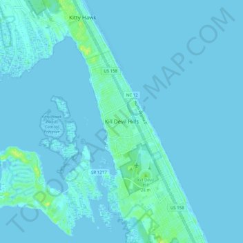
Name: Kill Devil Hills topographic map, elevation, terrain.
Average elevation: 1 m
Minimum elevation: -4 m
Maximum elevation: 15 m
First Flight Airport covers an area of 40 acres at an elevation of 13 feet (4 metres) above mean sea level. It has one runway; designated 2/20, with an asphalt surface measuring 3,000 by 60 feet (914 by 18 metres). For the 12-month period ending August 19, 2009, the airport had 38,120 aircraft operations, an average of 104 per day: 97% general aviation, 3% air taxi, and <1% military.