Geolocate

Harris topographic map

Interactive map

Click on the map to display elevation.

About this map

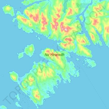
Name: Harris topographic map, elevation, terrain.

Location: Harris, Western Isles, Scotland, United Kingdom (57.72769 -7.13359 58.05170 -6.66408)

Average elevation: 74 m

Minimum elevation: -1 m

Maximum elevation: 788 m

Western Isles trails, hiking, mountain biking, running and outdoor activities

Other topographic maps

Click on a map to view its topography, its elevation and its terrain.

North Rona

United Kingdom > Scotland > Western Isles

Rona (Scottish Gaelic: Rònaigh) is an uninhabited Scottish island in the North Atlantic. It is often referred to as North Rona to distinguish it from the island of South Rona in the Inner Hebrides. It has an area of 109 hectares (270 acres) and a maximum elevation of 108 metres (354 ft).

Average elevation: 4 m

Cliasmol

United Kingdom > Scotland > Western Isles

Average elevation: 87 m

Clisham

United Kingdom > Scotland > Western Isles

Average elevation: 419 m

Lingay

United Kingdom > Scotland > Western Isles

Average elevation: 1 m

Daliburgh

United Kingdom > Scotland > Western Isles

Average elevation: 13 m

Rockall

United Kingdom > Scotland > Western Isles

Average elevation: 0 m

Liniclate

United Kingdom > Scotland > Western Isles

Average elevation: 4 m

Shulishader

United Kingdom > Scotland > Western Isles

Average elevation: 33 m

Nunton

United Kingdom > Scotland > Western Isles

Average elevation: 3 m

Carrigreich

United Kingdom > Scotland > Western Isles

Average elevation: 69 m

Kershader

United Kingdom > Scotland > Western Isles

Average elevation: 25 m

Balallan

United Kingdom > Scotland > Western Isles

Average elevation: 36 m

Callanish

United Kingdom > Scotland > Western Isles

Average elevation: 19 m

Askernish

United Kingdom > Scotland > Western Isles

Average elevation: 11 m

Scarista

United Kingdom > Scotland > Western Isles

Average elevation: 60 m

Carloway

United Kingdom > Scotland > Western Isles

Average elevation: 46 m

Reef

United Kingdom > Scotland > Western Isles

Average elevation: 18 m

Boreray

United Kingdom > Scotland > Western Isles

Average elevation: 4 m

Port of Ness

United Kingdom > Scotland > Western Isles

Average elevation: 19 m

Sandwick

United Kingdom > Scotland > Western Isles

Average elevation: 7 m

Kennavay

United Kingdom > Scotland > Western Isles

Average elevation: 9 m

Stornoway

United Kingdom > Scotland > Western Isles

Average elevation: 34 m

Balivanich

United Kingdom > Scotland > Western Isles

Average elevation: 3 m

Loch Langavat

United Kingdom > Scotland > Western Isles

Average elevation: 96 m

Gravir

United Kingdom > Scotland > Western Isles

Average elevation: 76 m

Linshader

United Kingdom > Scotland > Western Isles

Average elevation: 21 m

Craigston

United Kingdom > Scotland > Western Isles > Borve

Average elevation: 66 m

Lochboisdale

United Kingdom > Scotland > Western Isles

Average elevation: 37 m

Kildonan

United Kingdom > Scotland > Western Isles

Average elevation: 13 m

Dùn

United Kingdom > Scotland > Western Isles

Average elevation: 11 m

Ledaig

United Kingdom > Scotland > Western Isles > Castlebay

Average elevation: 59 m

Achmore

United Kingdom > Scotland > Western Isles

Average elevation: 91 m

Habost

United Kingdom > Scotland > Western Isles

Average elevation: 35 m

Bogach

United Kingdom > Scotland > Western Isles > Northbay > Bogach

Average elevation: 32 m