
Sköns distrikt topographic map
Interactive map
Click on the map to display elevation.
About this map
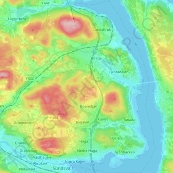
Name: Sköns distrikt topographic map, elevation, terrain.
Average elevation: 54 m
Minimum elevation: -1 m
Maximum elevation: 185 m
Other topographic maps
Click on a map to view its topography, its elevation and its terrain.
Ortviken
Suède > Comté de Västernorrland > Sköns distrikt
Ortviken, Heffners-Ortviken, Sköns distrikt, Sundsvalls kommun, Comté de Västernorrland, Norrland, Suède
Average elevation: 15 m