Geolocate

Forbesganj topographic map

Click on the map to display elevation.

Forbesganj

Forbesganj is located at 26°18′N 87°15′E / 26.3°N 87.25°E / 26.3; 87.25. It has an average elevation of 46 meters (150 feet). The Nepalese border is only 12 km away.

Wikipedia (CC-BY-SA 3.0)

About this map

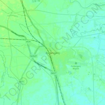
Name: Forbesganj topographic map, elevation, terrain.

Location: Forbesganj, Araria, Bihar, 854318, India (26.26491 87.22328 26.34491 87.30328)

Average elevation: 61 m

Minimum elevation: 56 m

Maximum elevation: 65 m

Gear up for your next adventure:

🧤Waterproof Overmitts - Extreme weather protection for hikers and mountaineers
🖼️Topographic Map Art - Decorative 3D-effect posters of famous UK peaks and regions
🧭Orienteering Compasses - Accurate compasses for map-based navigation
🥾Hiking Boots - Waterproof and durable boots for long-distance hiking in the UK
📱Phone Mounts for Hiking - Secure mounts to carry your phone on trails

As an Amazon Associate, this site earns from qualifying purchases at no extra cost to you.