
Obio/Akpor topographic map
Interactive map
Click on the map to display elevation.
About this map
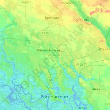
Name: Obio/Akpor topographic map, elevation, terrain.
Location: Obio/Akpor, Rivers State, Nigeria (4.79205 6.89268 4.93978 7.15240)
Average elevation: 14 m
Minimum elevation: -3 m
Maximum elevation: 45 m
Covering around 90 sq mi (230 km2), Obio-Akpor is generally a lowland area with average elevation below 30 metres above sea level. Its geology comprises basically of alluvial sedimentary basin and basement complex. The thick mangrove forest, raffia palms and light rainforest are the major types of vegetation. Due to high rainfall, the soil in the area is usually sandy or sandy loam. It is always leached, underlain by a layer of impervious pan.
Other topographic maps
Click on a map to view its topography, its elevation and its terrain.
Aoanta
Nigeria > Rivers State > Ikwerre > Aoanta
Aoanta, Ikwerre, Rivers State, Nigeria
Average elevation: 13 m