
Make a donation
Gear up for your next adventure:
As an Amazon Associate, this site earns from qualifying purchases at no extra cost to you.
Zuidwending topographic map
Click on the map to display elevation.
Make a donation
Gear up for your next adventure:
As an Amazon Associate, this site earns from qualifying purchases at no extra cost to you.
Zuidwending
De opslag bestaat uit een gasinstallatie bovengronds en uit vijf cavernes, waarvan er in 2011 vier gereed waren en de laatste in 2013 gereed gekomen is. De cavernes liggen op een diepte van 1000 tot 1500 meter. Vier cavernes hebben een gemiddelde hoogte van 300 meter en een diameter van 50 tot 60 meter en hebben per stuk een werkgasvolume van ongeveer 50 miljoen m³. De vijfde caverne heeft een hoogte van 500 meter en een doorsnede van zo’n 80 meter. Het kussengas houdt de gasdruk op 180 bar.
Make a donation
Gear up for your next adventure:
As an Amazon Associate, this site earns from qualifying purchases at no extra cost to you.
About this map
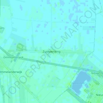
Name: Zuidwending topographic map, elevation, terrain.
Location: Zuidwending, Veendam, Groningen, Nederland, 9644 XE, Nederland (53.07552 6.91318 53.11552 6.95318)
Average elevation: 2 m
Minimum elevation: -2 m
Maximum elevation: 8 m
Make a donation
Gear up for your next adventure:
As an Amazon Associate, this site earns from qualifying purchases at no extra cost to you.