
Make a donation
Gear up for your next adventure:
As an Amazon Associate, this site earns from qualifying purchases at no extra cost to you.
Amherst topographic map
Click on the map to display elevation.
Make a donation
Gear up for your next adventure:
As an Amazon Associate, this site earns from qualifying purchases at no extra cost to you.
Amherst
According to the United States Census Bureau, the town has a total area of 34.4 square miles (89.1 km2), of which 33.9 square miles (87.8 km2) are land and 0.50 square miles (1.3 km2), or 1.49% of the total area, are water. The entire town is part of the Merrimack River watershed. The Souhegan River, an east-flowing tributary of the Merrimack, passes through the southern part of the town, and the Souhegan's tributary Beaver Brook drains the central part of town and passes through the main village. Baboosic Lake is farther north, along the eastern border of the town and is fed by Joe English Brook. The lake drains to the east into Baboosic Brook, a tributary of the Merrimack. Pulpit Brook, which drains the northeastern corner of the town, flows into Baboosic Brook as well. Witches Brook flows through the southernmost part of the town and is a tributary of Pennichuck Brook, yet another tributary of the Merrimack. Amherst's highest point is on Chestnut Hill at the town's northern border, where the elevation reaches 865 feet (264 m) above sea level.
Make a donation
Gear up for your next adventure:
As an Amazon Associate, this site earns from qualifying purchases at no extra cost to you.
About this map
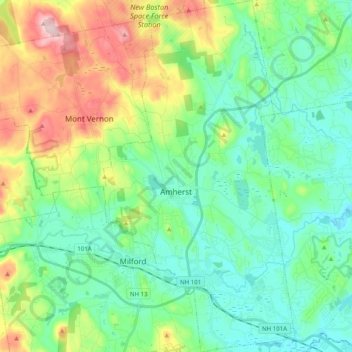
Name: Amherst topographic map, elevation, terrain.
Average elevation: 127 m
Minimum elevation: 51 m
Maximum elevation: 320 m
Make a donation
Gear up for your next adventure:
As an Amazon Associate, this site earns from qualifying purchases at no extra cost to you.
Other topographic maps
Click on a map to view its topography, its elevation and its terrain.
New Ipswich Center
United States > New Hampshire > Hillsborough County > New Ipswich
Average elevation: 324 m
Souhegan River Watershed Dam Number 35
United States > New Hampshire > Hillsborough County > New Ipswich > Smithville
Average elevation: 349 m
Make a donation
Gear up for your next adventure:
As an Amazon Associate, this site earns from qualifying purchases at no extra cost to you.
South Uncanoonuc Mountain
United States > New Hampshire > Hillsborough County > Goffstown
Average elevation: 243 m
Piscataquog River
United States > New Hampshire > Hillsborough County > Manchester
Average elevation: 59 m
Souhegan River
United States > New Hampshire > Hillsborough County > Milford > East Milford
Average elevation: 84 m
Make a donation
Gear up for your next adventure:
As an Amazon Associate, this site earns from qualifying purchases at no extra cost to you.
West Peterborough
United States > New Hampshire > Hillsborough County > Peterborough
Average elevation: 299 m
Souhegan River
United States > New Hampshire > Hillsborough County > Milford > East Milford
Average elevation: 84 m
Joe English Hill
United States > New Hampshire > Hillsborough County > New Boston
Average elevation: 247 m
Make a donation
Gear up for your next adventure:
As an Amazon Associate, this site earns from qualifying purchases at no extra cost to you.
Hillsboro Lower Village
United States > New Hampshire > Hillsborough County > Hillsborough
Average elevation: 242 m
Campbell Mountain
United States > New Hampshire > Hillsborough County > Hillsborough
Average elevation: 338 m
North Village
United States > New Hampshire > Hillsborough County > Peterborough
Average elevation: 251 m
Nakuru Lake
United States > New Hampshire > Hillsborough County > Hudson > Hudson Center
Average elevation: 80 m
Make a donation
Gear up for your next adventure:
As an Amazon Associate, this site earns from qualifying purchases at no extra cost to you.
South Weare
United States > New Hampshire > Hillsborough County > Weare > South Weare
Average elevation: 210 m
North Brookline
United States > New Hampshire > Hillsborough County > Brookline > North Brookline
Average elevation: 124 m
Massachusetts Drive Park
United States > New Hampshire > Hillsborough County > Nashua
Average elevation: 48 m