
Make a donation
Gear up for your next adventure:
As an Amazon Associate, this site earns from qualifying purchases at no extra cost to you.
Ulaangom topographic map
Click on the map to display elevation.
Make a donation
Gear up for your next adventure:
As an Amazon Associate, this site earns from qualifying purchases at no extra cost to you.
Ulaangom
Ulaangom experiences an extremely continental cold semi-arid climate (Köppen BSk) with long, dry, frigid winters and short, warm summers. Precipitation is very low, with an annual average of 130 millimetres or 5.12 inches. Owing to its location in a deep valley near the center of the Siberian High, Ulaangom is subject to temperature inversions reaching up to 13.0 °C or 23.4 °F colder than middle and upper mountain slopes. It is thus one of the coldest places in Mongolia despite lying at a lower altitude than most of the country. Temperatures can reach −45 °C (−49 °F) or lower in the winter and 35 °C (95 °F) or more in the summer.
Make a donation
Gear up for your next adventure:
As an Amazon Associate, this site earns from qualifying purchases at no extra cost to you.
About this map
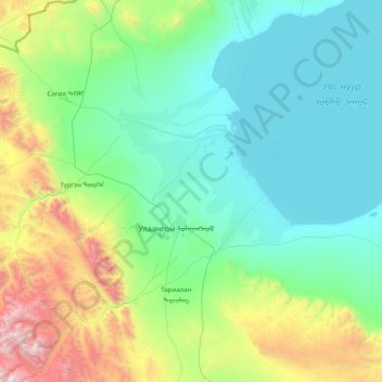
Name: Ulaangom topographic map, elevation, terrain.
Location: Ulaangom, Uvs, Mongolia (49.56628 91.26824 50.58723 92.47821)
Average elevation: 1,364 m
Minimum elevation: 756 m
Maximum elevation: 4,002 m
Make a donation
Gear up for your next adventure:
As an Amazon Associate, this site earns from qualifying purchases at no extra cost to you.