
Make a donation
Gear up for your next adventure:
As an Amazon Associate, this site earns from qualifying purchases at no extra cost to you.
Neyshabur City topographic map
Click on the map to display elevation.
Make a donation
Gear up for your next adventure:
As an Amazon Associate, this site earns from qualifying purchases at no extra cost to you.
Neyshabur City
Nishapur is located at an elevation of 1250 meters on a wide fertile plain at the southwestern foot of the Binalud Mountain range in northcentral Razavi Khorasan Province. The city is connected by both railways and highways to the cities of Mashhad and Tehran. The city also has local routes and highways to the cities of Kashmar and Quchan.
Make a donation
Gear up for your next adventure:
As an Amazon Associate, this site earns from qualifying purchases at no extra cost to you.
About this map
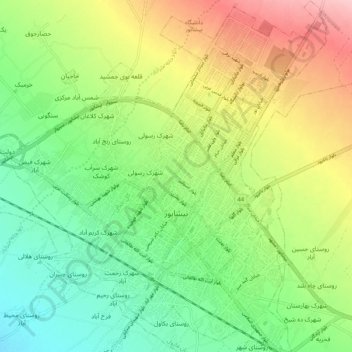
Name: Neyshabur City topographic map, elevation, terrain.
Average elevation: 1,208 m
Minimum elevation: 1,147 m
Maximum elevation: 1,302 m
Make a donation
Gear up for your next adventure:
As an Amazon Associate, this site earns from qualifying purchases at no extra cost to you.
Other topographic maps
Click on a map to view its topography, its elevation and its terrain.