
Schlachtensee topographic map
Interactive map
Click on the map to display elevation.
About this map
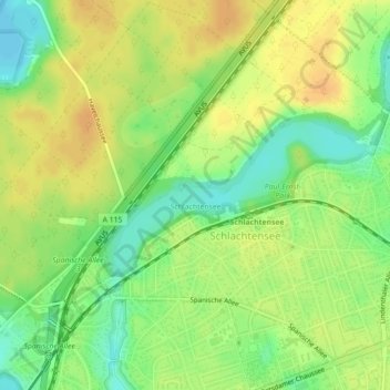
Name: Schlachtensee topographic map, elevation, terrain.
Location: Schlachtensee, Steglitz-Zehlendorf, Berlin, 14129, Germany (52.43612 13.19920 52.44639 13.22814)
Average elevation: 47 m
Minimum elevation: 29 m
Maximum elevation: 60 m
Other topographic maps
Click on a map to view its topography, its elevation and its terrain.
Berlin
Berlin straddles the banks of the River Spree, which flows into the River Havel (a tributary of the River Elbe) in the western borough of Spandau. Among the city's main topographical features are the many lakes in the western and southeastern boroughs formed by the Spree, Havel, and Dahme rivers (the largest…
Average elevation: 47 m