
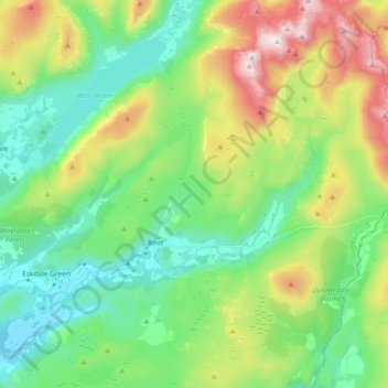
Eskdale topographic map
Interactive map
Click on the map to display elevation.
About this map
Name: Eskdale topographic map, elevation, terrain.
Average elevation: 310 m
Minimum elevation: 8 m
Maximum elevation: 970 m
Other topographic maps
Click on a map to view its topography, its elevation and its terrain.
Wast Water
United Kingdom > England > Copeland
Wast Water, Netherbeck Bridge, Wasdale, Copeland, Cumbria, North West England, England, CA20 1EX, United Kingdom
Average elevation: 239 m
Whitehaven
United Kingdom > England > Copeland > Whitehaven
Whitehaven, Copeland, Cumbria, North West England, England, CA28 7AY, United Kingdom
Average elevation: 54 m
Wasdale
United Kingdom > England > Copeland > Nether Wasdale
Wasdale, Nether Wasdale, Copeland, Cumbria, North West England, England, CA20 1EX, United Kingdom
Average elevation: 329 m
Sineytarn Moss
United Kingdom > England > Copeland
Sineytarn Moss, Eskdale, Copeland, Cumbria, North West England, England, CA19 1TF, United Kingdom
Average elevation: 149 m
Beckermet
United Kingdom > England > Copeland > Beckermet
Beckermet, Copeland, Cumbria, North West England, England, CA21 2YB, United Kingdom
Average elevation: 43 m
Black Comb
United Kingdom > England > Copeland
Black Comb, Wasdale, Copeland, Cumbria, North West England, England, CA20 1EX, United Kingdom
Average elevation: 584 m
Moresby Parks
United Kingdom > England > Copeland > Moresby Parks
Moresby Parks, Copeland, Cumbria, North West England, England, CA28 8XW, United Kingdom
Average elevation: 116 m
Barrow
United Kingdom > England > Copeland
Barrow, Copeland, Cumbria, North West England, England, LA18 5LA, United Kingdom
Average elevation: 150 m
Ennerdale Water
United Kingdom > England > Copeland
Ennerdale Water, Smithy Beck Trail, Ennerdale and Kinniside, Copeland, Cumbria, North West England, England, CA23 3AU, United Kingdom
Average elevation: 261 m
Fell End
United Kingdom > England > Copeland
Fell End, Copeland, Cumbria, North West England, England, CA19 1TS, United Kingdom
Average elevation: 127 m
Muncaster
United Kingdom > England > Copeland
Muncaster, Copeland, Cumbria, North West England, England, United Kingdom
Average elevation: 100 m
Ennerdale
United Kingdom > England > Copeland
Ennerdale, Mosedale, Wasdale, Copeland, Cumbria, North West England, England, CA20 1EX, United Kingdom
Average elevation: 367 m
Slight Side
United Kingdom > England > Copeland
Slight Side, Copeland, Cumbria, North West England, England, CA20 1EX, United Kingdom
Average elevation: 518 m
Green Gable
United Kingdom > England > Copeland
Green Gable, Copeland, Cumbria, North West England, England, CA12 5XJ, United Kingdom
Average elevation: 531 m
River Liza
United Kingdom > England > Copeland
River Liza, Copeland, Cumbria, North West England, England, CA23 3AU, United Kingdom
Average elevation: 258 m
Illgill Head
United Kingdom > England > Copeland
Illgill Head, Copeland, Cumbria, North West England, England, CA19 1UF, United Kingdom
Average elevation: 311 m
Great How
United Kingdom > England > Copeland
Great How, Copeland, Cumbria, North West England, England, CA19 1TH, United Kingdom
Average elevation: 384 m
Lowca Beck
United Kingdom > England > Copeland
Lowca Beck, Copeland, Cumbria, North West England, England, CA14 5SR, United Kingdom
Average elevation: 92 m
Seatallan
United Kingdom > England > Copeland
Seatallan, Copeland, Cumbria, North West England, England, CA20 1EU, United Kingdom
Average elevation: 452 m
River Bleng
United Kingdom > England > Copeland
River Bleng, Copeland, Cumbria, North West England, England, CA20 1JB, United Kingdom
Average elevation: 54 m
Copeland Forest
United Kingdom > England > Copeland
Copeland Forest, Copeland, Cumbria, North West England, England, CA20 1EX, United Kingdom
Average elevation: 467 m
Howgill Wood
United Kingdom > England > Copeland
Howgill Wood, Copeland, Cumbria, North West England, England, CA14 4TY, United Kingdom
Average elevation: 238 m
River Irt
United Kingdom > England > Copeland
River Irt, Copeland, Cumbria, North West England, England, CA20 1ES, United Kingdom
Average elevation: 79 m
River Keekle
United Kingdom > England > Copeland
River Keekle, Copeland, Cumbria, North West England, England, CA25 5RH, United Kingdom
Average elevation: 110 m