Geolocate

Astley topographic map

Click on the map to display elevation.

About this map
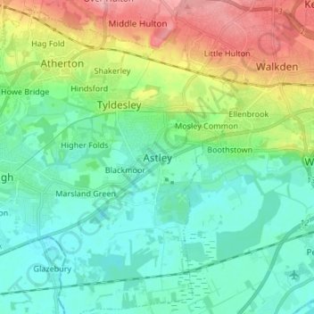
Name: Astley topographic map, elevation, terrain.

Location: Astley, Wigan, Greater Manchester, England, M29 7HT, United Kingdom (53.46100 -2.48969 53.54100 -2.40969)

Average elevation: 44 m

Minimum elevation: 12 m

Maximum elevation: 121 m

Other topographic maps

Click on a map to view its topography, its elevation and its terrain.
Shevington

United Kingdom > England > Wigan

Average elevation: 70 m

Gear up for your next adventure:

🧵Survival Paracord - Multi-purpose cordage for emergency repairs and shelters
🔋Solar Power Banks - Keep your GPS and phone charged during multi-day expeditions
📦Compression Sacks - Reduce backpack volume efficiently
🔦Waterproof LED Headlamps - Hands-free lighting for evening treks and emergency navigation
🌦️Portable Weather Meters - Handheld tools for monitoring weather conditions

As an Amazon Associate, this site earns from qualifying purchases at no extra cost to you.