
Richardson Mountains topographic map
Interactive map
Click on the map to display elevation.
About this map
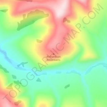
Name: Richardson Mountains topographic map, elevation, terrain.
Location: Richardson Mountains, Yukon, Canada (66.90281 -136.14951 66.90291 -136.14941)
Average elevation: 679 m
Minimum elevation: 538 m
Maximum elevation: 889 m
Other topographic maps
Click on a map to view its topography, its elevation and its terrain.
Kluane National Park and Reserve
Kluane National Park and Reserve, Yukon, Canada
Average elevation: 1,536 m
Two Mile Village
Canada > Yukon > Watson Lake
Two Mile Village, Watson Lake, Yukon, Y0A 1C0, Canada
Average elevation: 703 m
Destruction Bay
Canada > Yukon > Destruction Bay
Destruction Bay, Yukon, Y0B 1H0, Canada
Average elevation: 893 m
Dawson City
Canada > Yukon > Dawson City > Dawson City
Dawson City, Yukon, Y0B 1G0, Canada
Average elevation: 510 m
Yukon, Unorganized
City of Whitehorse, Yukon, Unorganized, Yukon, Canada
Average elevation: 1,010 m
Swift River
Canada > Yukon > Swift River
Swift River, Yukon, Unorganized, Yukon, Canada
Average elevation: 1,086 m