
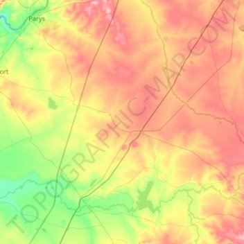
Ngwathe Ward 18 topographic map
Interactive map
Click on the map to display elevation.
About this map
Name: Ngwathe Ward 18 topographic map, elevation, terrain.
Average elevation: 1,443 m
Minimum elevation: 1,340 m
Maximum elevation: 1,575 m
Other topographic maps
Click on a map to view its topography, its elevation and its terrain.
Heilbron
South Africa > Free State > Fezile Dabi District Municipality > Ngwathe Local Municipality
Heilbron, Ngwathe Local Municipality, Fezile Dabi District Municipality, Free State, South Africa
Average elevation: 1,559 m
Vredefort
South Africa > Free State > Fezile Dabi District Municipality > Ngwathe Local Municipality
Vredefort, Ngwathe Local Municipality, Fezile Dabi District Municipality, Free State, 9595, South Africa
Average elevation: 1,430 m