
City of Niš topographic map
Interactive map
Click on the map to display elevation.
About this map
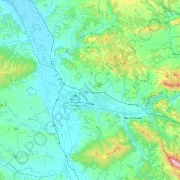
Name: City of Niš topographic map, elevation, terrain.
Average elevation: 405 m
Minimum elevation: 164 m
Maximum elevation: 1,794 m
Other topographic maps
Click on a map to view its topography, its elevation and its terrain.
Rautovo
Serbia > Central Serbia > Nisava Administrative District > City of Niš
Rautovo, Градска општина Нишка Бања, City of Niš, Nisava Administrative District, Central Serbia, Serbia
Average elevation: 587 m
Прекоп
Serbia > Central Serbia > Nisava Administrative District > City of Niš
Прекоп, City of Niš, Nisava Administrative District, Central Serbia, Serbia
Average elevation: 659 m