
Make a donation
Gear up for your next adventure:
As an Amazon Associate, this site earns from qualifying purchases at no extra cost to you.
Ukhrul topographic map
Click on the map to display elevation.
Make a donation
Gear up for your next adventure:
As an Amazon Associate, this site earns from qualifying purchases at no extra cost to you.
Ukhrul
Ukhrul is located at 25°07′N 94°22′E / 25.12°N 94.37°E / 25.12; 94.37. It has an average elevation of 1,662 m (5,453 ft) above sea level. It has a wet summer and cold, dry winter.
Make a donation
Gear up for your next adventure:
As an Amazon Associate, this site earns from qualifying purchases at no extra cost to you.
About this map
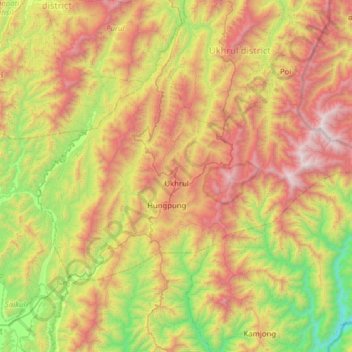
Name: Ukhrul topographic map, elevation, terrain.
Location: Ukhrul, Ukhrul district, Manipur, India (24.93007 94.11643 25.28856 94.74068)
Average elevation: 1,340 m
Minimum elevation: 305 m
Maximum elevation: 2,800 m
Make a donation
Gear up for your next adventure:
As an Amazon Associate, this site earns from qualifying purchases at no extra cost to you.
Other topographic maps
Click on a map to view its topography, its elevation and its terrain.
Make a donation
Gear up for your next adventure:
As an Amazon Associate, this site earns from qualifying purchases at no extra cost to you.
Make a donation
Gear up for your next adventure:
As an Amazon Associate, this site earns from qualifying purchases at no extra cost to you.
Make a donation
Gear up for your next adventure:
As an Amazon Associate, this site earns from qualifying purchases at no extra cost to you.