
Make a donation
Gear up for your next adventure:
As an Amazon Associate, this site earns from qualifying purchases at no extra cost to you.
Patos topographic map
Click on the map to display elevation.
Make a donation
Gear up for your next adventure:
As an Amazon Associate, this site earns from qualifying purchases at no extra cost to you.
About this map
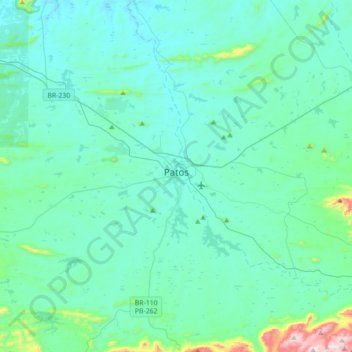
Name: Patos topographic map, elevation, terrain.
Location: Patos, Paraíba, Northeast Region, Brazil (-7.15423 -37.52454 -6.90519 -37.17268)
Average elevation: 292 m
Minimum elevation: 201 m
Maximum elevation: 991 m
Make a donation
Gear up for your next adventure:
As an Amazon Associate, this site earns from qualifying purchases at no extra cost to you.
Other topographic maps
Click on a map to view its topography, its elevation and its terrain.
Campina Grande
Brazil > Paraíba > Região Metropolitana de Campina Grande > Campina Grande
Average elevation: 498 m
Serra da Borborema
Brazil > Paraíba > Região Metropolitana de Patos > Cacimbas
Average elevation: 573 m
Make a donation
Gear up for your next adventure:
As an Amazon Associate, this site earns from qualifying purchases at no extra cost to you.