
Thank you for supporting this site ❤️
Make a donation
Make a donation
Gear up for your next adventure:
As an Amazon Associate, this site earns from qualifying purchases at no extra cost to you.
Çamdibi topographic map
Click on the map to display elevation.
Thank you for supporting this site ❤️
Make a donation
Make a donation
Gear up for your next adventure:
As an Amazon Associate, this site earns from qualifying purchases at no extra cost to you.
About this map
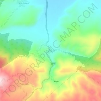
Name: Çamdibi topographic map, elevation, terrain.
Location: Çamdibi, Refahiye, Erzincan, Eastern Anatolia Region, Turkey (39.82826 38.73694 39.86826 38.77694)
Average elevation: 1,770 m
Minimum elevation: 1,617 m
Maximum elevation: 2,021 m
Thank you for supporting this site ❤️
Make a donation
Make a donation
Gear up for your next adventure:
As an Amazon Associate, this site earns from qualifying purchases at no extra cost to you.