Geolocate

Glynneath topographic map

Click on the map to display elevation.

About this map

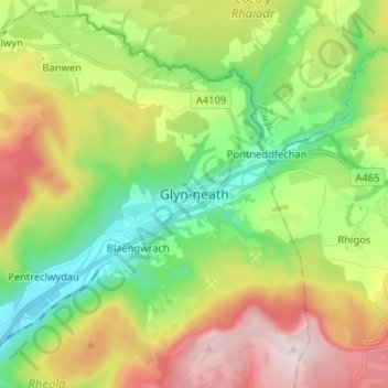
Name: Glynneath topographic map, elevation, terrain.

Location: Glynneath, Neath Port Talbot, Wales, SA11 5AY, United Kingdom (51.70841 -3.65693 51.78841 -3.57693)

Average elevation: 253 m

Minimum elevation: 26 m

Maximum elevation: 603 m

Neath Port Talbot trails, hiking, mountain biking, running and outdoor activities

Other topographic maps

Click on a map to view its topography, its elevation and its terrain.

River Neath

United Kingdom > Wales > Neath Port Talbot > Resolven

Average elevation: 272 m

Glynneath

United Kingdom > Wales > Neath Port Talbot

Average elevation: 246 m

Cilybebyll

United Kingdom > Wales > Neath Port Talbot > Gellinudd

Average elevation: 179 m

Pelenna

United Kingdom > Wales > Neath Port Talbot

Average elevation: 217 m

Crynant

United Kingdom > Wales > Neath Port Talbot

Average elevation: 232 m

Neath

United Kingdom > Wales > Neath Port Talbot

Average elevation: 71 m

Pontardawe

United Kingdom > Wales > Neath Port Talbot

Average elevation: 180 m

Gear up for your next adventure:

📍Handheld GPS Navigators - Reliable satellite navigation for hiking and off-road exploration
🧢Thermal Beanie Hats - Prevent heat loss from the head in windy summit conditions
🥼Base Layers - Thermal base layers for temperature regulation
🔦Waterproof LED Headlamps - Hands-free lighting for evening treks and emergency navigation
🦯Walking Poles - Supportive poles for long-distance walking

As an Amazon Associate, this site earns from qualifying purchases at no extra cost to you.