
Pic oriental de Coll Roig topographic map
Interactive map
Click on the map to display elevation.
About this map
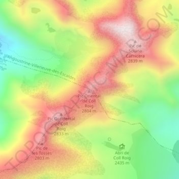
Name: Pic oriental de Coll Roig topographic map, elevation, terrain.
Average elevation: 2,535 m
Minimum elevation: 2,169 m
Maximum elevation: 2,877 m
Other topographic maps
Click on a map to view its topography, its elevation and its terrain.
Coma d'en Garcia
France > Occitanie > Pyrénées-Orientales > Porté-Puymorens
Coma d'en Garcia, Porté-Puymorens, Prades, Pyrénées-Orientales, Occitanie, France métropolitaine, 66760, France
Average elevation: 2,206 m
Col de Puymorens
France > Occitanie > Pyrénées-Orientales > Porté-Puymorens
Col de Puymorens, Porté-Puymorens, Prades, Pyrénées-Orientales, Occitanie, France métropolitaine, 66760, France
Average elevation: 1,972 m