Geolocate

Gerona topographic map

Click on the map to display elevation.

About this map

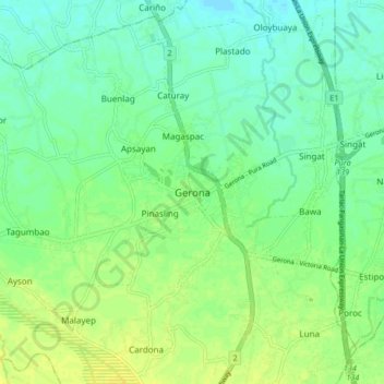
Name: Gerona topographic map, elevation, terrain.

Location: Gerona, Tarlac, Central Luzon, 2302, Philippines (15.56693 120.55857 15.64693 120.63857)

Average elevation: 26 m

Minimum elevation: 18 m

Maximum elevation: 35 m

Other topographic maps

Click on a map to view its topography, its elevation and its terrain.

Paniqui

Philippines > Tarlac

Average elevation: 20 m

San Jose

Philippines > Tarlac

Average elevation: 186 m

Ramos

Philippines > Tarlac

Average elevation: 19 m

Moncada

Philippines > Tarlac

Average elevation: 17 m

San Manuel

Philippines > Tarlac

Average elevation: 26 m

La Paz

Philippines > Tarlac

Average elevation: 22 m

Concepcion

Philippines > Tarlac

Average elevation: 36 m

Capas

Philippines > Tarlac > Capas

Average elevation: 260 m

Gear up for your next adventure:

🪢Paracord - Multi-purpose cord for camping and survival
📱Phone Mounts for Hiking - Secure mounts to carry your phone on trails
🧣Neck Gaiters - Protects against wind and sun on exposed ridges and peaks
GPS Outdoor Watches - Watches with GPS tracking for hiking and exploration
🥾Men's Waterproof Hiking Boots - Durable footwear with deep lugs for muddy and rocky UK terrains

As an Amazon Associate, this site earns from qualifying purchases at no extra cost to you.