
San Joaquin topographic map
Interactive map
Click on the map to display elevation.
About this map
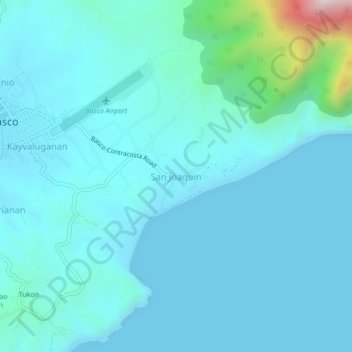
Name: San Joaquin topographic map, elevation, terrain.
Average elevation: 87 m
Minimum elevation: 0 m
Maximum elevation: 805 m
Other topographic maps
Click on a map to view its topography, its elevation and its terrain.
Kayhuvokan
Philippines > Batanes > Basco
Kayhuvokan, Basco, Batanes, Cagayan Valley, 3900, Philippines
Average elevation: 55 m
Batan Islands
Philippines > Batanes > Basco
Batan Islands, Basco, Batanes, Cagayan Valley, 3900, Philippines
Average elevation: 0 m