
Thank you for supporting this site ❤️
Make a donation
Make a donation
Gear up for your next adventure:
As an Amazon Associate, this site earns from qualifying purchases at no extra cost to you.
Mazeras topographic map
Click on the map to display elevation.
Thank you for supporting this site ❤️
Make a donation
Make a donation
Gear up for your next adventure:
As an Amazon Associate, this site earns from qualifying purchases at no extra cost to you.
About this map
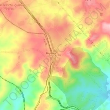
Name: Mazeras topographic map, elevation, terrain.
Location: Mazeras, Rabai/Kisurutini ward, Rabai, Kilifi County, Kenya (-3.98757 39.52981 -3.94757 39.56981)
Average elevation: 132 m
Minimum elevation: 30 m
Maximum elevation: 213 m
Thank you for supporting this site ❤️
Make a donation
Make a donation
Gear up for your next adventure:
As an Amazon Associate, this site earns from qualifying purchases at no extra cost to you.