
Enfield topographic map
Interactive map
Click on the map to display elevation.
Enfield
According to the United States Census Bureau, the town has a total area of 43.1 square miles (111.6 km2), of which 40.3 sq mi (104.3 km2) is land and 2.9 sq mi (7.4 km2) is water, comprising 6.59% of the town. Enfield is drained by the Mascoma River. Mascoma Lake, in the west, represents Enfield's lowest elevation at 751 feet (229 m) above sea level. The highest elevation is over 2,100 ft (640 m) at the summit of Prospect Hill, overlooking Halfmile Pond. Crystal Lake is in the east. Enfield lies fully within the Connecticut River watershed.
About this map
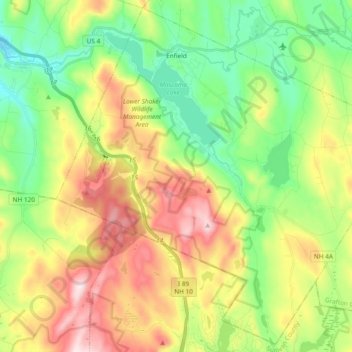
Name: Enfield topographic map, elevation, terrain.
Location: Enfield, Grafton County, New Hampshire, United States (43.52894 -72.20815 43.65909 -72.02010)
Average elevation: 366 m
Minimum elevation: 178 m
Maximum elevation: 654 m
Other topographic maps
Click on a map to view its topography, its elevation and its terrain.
Stinson Lake
United States > New Hampshire > Grafton County > Rumney > Stinson Lake
Average elevation: 460 m
Mount Kineo, East Peak
United States > New Hampshire > Grafton County > Ellsworth
Average elevation: 710 m
West Lebanon
United States > New Hampshire > Grafton County > Lebanon > West Lebanon
Average elevation: 165 m
North Littleton
United States > New Hampshire > Grafton County > Littleton > North Littleton
Average elevation: 333 m
LeBruns Mobile Home Park
United States > New Hampshire > Grafton County > Lebanon > LeBruns Mobile Home Park
Average elevation: 326 m