
Thank you for supporting this site ❤️
Make a donation
Make a donation
Gear up for your next adventure:
As an Amazon Associate, this site earns from qualifying purchases at no extra cost to you.
Tregeiriog topographic map
Click on the map to display elevation.
Thank you for supporting this site ❤️
Make a donation
Make a donation
Gear up for your next adventure:
As an Amazon Associate, this site earns from qualifying purchases at no extra cost to you.
About this map
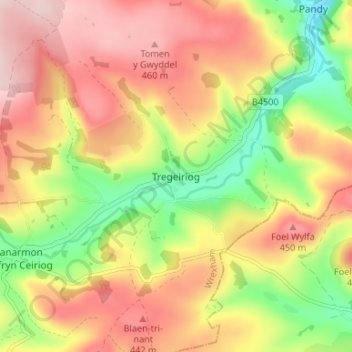
Name: Tregeiriog topographic map, elevation, terrain.
Location: Tregeiriog, Wrexham, Wales, LL20 7HY, United Kingdom (52.87564 -3.24408 52.91564 -3.20408)
Average elevation: 355 m
Minimum elevation: 200 m
Maximum elevation: 489 m
Wrexham trails, hiking, mountain biking, running and outdoor activities
Thank you for supporting this site ❤️
Make a donation
Make a donation
Gear up for your next adventure:
As an Amazon Associate, this site earns from qualifying purchases at no extra cost to you.