
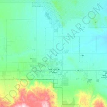
Twentynine Palms topographic map
Interactive map
Click on the map to display elevation.
About this map
Name: Twentynine Palms topographic map, elevation, terrain.
Average elevation: 690 m
Minimum elevation: 489 m
Maximum elevation: 1,546 m
According to the United States Census Bureau, the city has a total area of 59.1 square miles (153 km2), all land. The city is at an elevation of 1,988 feet (606 m). The Marine Corps Air Ground Combat Center Twentynine Palms is located there.
Other topographic maps
Click on a map to view its topography, its elevation and its terrain.
Twenty-Nine Palms Band
United States > California > San Bernardino County > Twentynine Palms
Twenty-Nine Palms Band, Twentynine Palms, San Bernardino County, California, United States
Average elevation: 899 m