
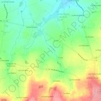
Sainte-Marie-du-Bois topographic map
Interactive map
Click on the map to display elevation.
About this map
Name: Sainte-Marie-du-Bois topographic map, elevation, terrain.
Average elevation: 147 m
Minimum elevation: 100 m
Maximum elevation: 213 m
Other topographic maps
Click on a map to view its topography, its elevation and its terrain.
Le Domaine
France > Normandie > Manche > Le Teilleul
Le Domaine, Le Teilleul, Avranches, Manche, Normandie, France métropolitaine, 50640, France
Average elevation: 167 m
La Butte Rouge
France > Normandie > Manche > Le Teilleul
La Butte Rouge, Le Teilleul, Avranches, Manche, Normandie, France métropolitaine, 50640, France
Average elevation: 176 m
Le Teilleul
France > Normandie > Manche > Le Teilleul
Le Teilleul, Avranches, Manche, Normandie, France métropolitaine, 50640, France
Average elevation: 169 m