Geolocate

Waco topographic map

Click on the map to display elevation.

About this map

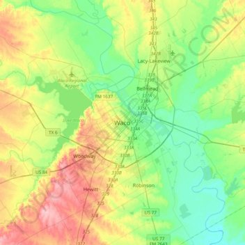
Name: Waco topographic map, elevation, terrain.

Location: Waco, McLennan County, Texas, 76701, United States (31.38933 -97.30667 31.70933 -96.98667)

Average elevation: 150 m

Minimum elevation: 104 m

Maximum elevation: 235 m

Gear up for your next adventure:

🧦Hiking Socks - Breathable socks designed to prevent blisters on long walks
🌄Outdoor Binoculars - Compact binoculars for landscape observation
📕Outdoor Navigation Books - Learn traditional and modern navigation techniques
🧭Orienteering Compasses - Accurate compasses for map-based navigation
🎒Hiking Child Carriers - Explore the outdoors with the whole family safely

As an Amazon Associate, this site earns from qualifying purchases at no extra cost to you.