
Al Mansura District topographic map
Interactive map
Click on the map to display elevation.
About this map
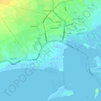
Name: Al Mansura District topographic map, elevation, terrain.
Location: Al Mansura District, Aden City, Aden Governorate, Yemen (12.79945 44.92312 12.88720 44.99882)
Average elevation: 6 m
Minimum elevation: -5 m
Maximum elevation: 33 m
Other topographic maps
Click on a map to view its topography, its elevation and its terrain.
Ash Shaykh `Uthman District
Yemen > Aden Governorate > Aden City
Ash Shaykh `Uthman District, Aden City, Aden Governorate, Yemen
Average elevation: 8 m
Khawr Maksar
Yemen > Aden Governorate > Aden City
Khawr Maksar, Khwar Maksar Dstrict, Aden City, Aden Governorate, Yemen
Average elevation: 0 m