
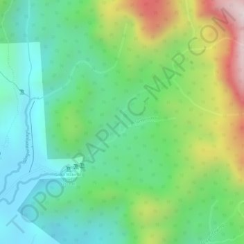
Sungai Gabai topographic map
Interactive map
Click on the map to display elevation.
About this map
Name: Sungai Gabai topographic map, elevation, terrain.
Average elevation: 292 m
Minimum elevation: 92 m
Maximum elevation: 665 m
Other topographic maps
Click on a map to view its topography, its elevation and its terrain.
Sungai Sekamat
Malaysia > Selangor > Kajang Municipal Council > Kampung Sungai Sekamat
Average elevation: 40 m
Bandar Baru Bangi
Malaysia > Selangor > Kajang Municipal Council > Bandar Baru Bangi
Average elevation: 47 m
Kampung Teras Jernang
Malaysia > Selangor > Kajang Municipal Council > Bangi Lama
Average elevation: 35 m
Kampung Sungai Semungkis
Malaysia > Selangor > Kajang Municipal Council > Kampung Batu 16
Average elevation: 85 m
Kampung Baru Balakong
Malaysia > Selangor > Kajang Municipal Council > Kampung Baru Balakong
Average elevation: 61 m
Sungai Sompo
Malaysia > Selangor > Kajang Municipal Council > Beranang > Kampung Tanjung
Average elevation: 43 m
Kampung Teras Jernang
Malaysia > Selangor > Kajang Municipal Council > Bangi Lama > Kampung Teras Jernang
Average elevation: 40 m
Kampung Sungai Serai
Malaysia > Selangor > Kajang Municipal Council > Batu 14 Hulu Langat
Average elevation: 127 m
Taman Permainan Bandar Teknologi Kajang
Malaysia > Selangor > Kajang Municipal Council > Semenyih
Average elevation: 63 m
Kampung Batu 10
Malaysia > Selangor > Kajang Municipal Council > Kampung Batu 10
Average elevation: 61 m