
Thank you for supporting this site ❤️
Make a donation
Make a donation
Gear up for your next adventure:
As an Amazon Associate, this site earns from qualifying purchases at no extra cost to you.
Longji topographic map
Click on the map to display elevation.
Thank you for supporting this site ❤️
Make a donation
Make a donation
Gear up for your next adventure:
As an Amazon Associate, this site earns from qualifying purchases at no extra cost to you.
About this map
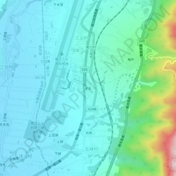
Name: Longji topographic map, elevation, terrain.
Location: Longji, Qihe, Gucheng District, Lijiang City, Yunnan, China (26.64917 100.23187 26.68917 100.27187)
Average elevation: 2,293 m
Minimum elevation: 2,202 m
Maximum elevation: 2,737 m
Thank you for supporting this site ❤️
Make a donation
Make a donation
Gear up for your next adventure:
As an Amazon Associate, this site earns from qualifying purchases at no extra cost to you.