
Make a donation
Gear up for your next adventure:
As an Amazon Associate, this site earns from qualifying purchases at no extra cost to you.
Satory topographic map
Click on the map to display elevation.
Make a donation
Gear up for your next adventure:
As an Amazon Associate, this site earns from qualifying purchases at no extra cost to you.
Satory
Satory se trouve dans la partie sud-ouest de la commune de Versailles. Le quartier occupe un plateau allongé à environ 175 m d'altitude, délimité au nord par la route nationale 12 et au sud par la vallée encaissée de la Bièvre qui prend sa source dans le hameau de Bouviers. Il est presque entièrement entouré d'une ceinture forestière, le bois de Satory au nord, la forêt domaniale de Versailles au sud et à l'ouest.
Make a donation
Gear up for your next adventure:
As an Amazon Associate, this site earns from qualifying purchases at no extra cost to you.
About this map
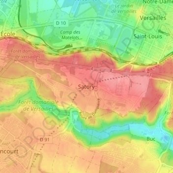
Name: Satory topographic map, elevation, terrain.
Average elevation: 148 m
Minimum elevation: 104 m
Maximum elevation: 183 m
Make a donation
Gear up for your next adventure:
As an Amazon Associate, this site earns from qualifying purchases at no extra cost to you.