
Ballard County topographic map
Interactive map
Click on the map to display elevation.
About this map
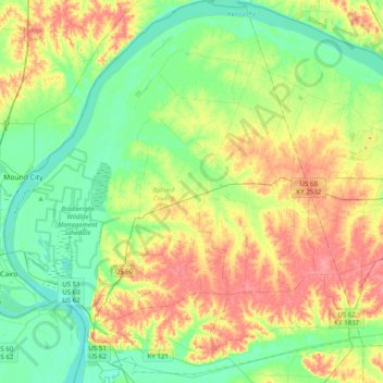
Name: Ballard County topographic map, elevation, terrain.
Location: Ballard County, Kentucky, États-Unis d'Amérique (36.91546 -89.18251 37.22989 -88.81583)
Average elevation: 113 m
Minimum elevation: 87 m
Maximum elevation: 153 m
Other topographic maps
Click on a map to view its topography, its elevation and its terrain.
Shelbyville
États-Unis d'Amérique > Kentucky > Shelbyville
Shelbyville, Shelby County, Kentucky, 40065, États-Unis d'Amérique
Average elevation: 232 m
Bowling Green
États-Unis d'Amérique > Kentucky > Bowling Green
Bowling Green, Warren County, Kentucky, 42101, États-Unis d'Amérique
Average elevation: 169 m
Georgetown
États-Unis d'Amérique > Kentucky > Georgetown
Georgetown, Scott County, Kentucky, 40324, États-Unis d'Amérique
Average elevation: 265 m
Medora
États-Unis d'Amérique > Kentucky > Medora
Medora, Jefferson County, Kentucky, 40272, États-Unis d'Amérique
Average elevation: 159 m
Fort Wright
États-Unis d'Amérique > Kentucky > Fort Wright
Fort Wright, Comté de Kenton, Kentucky, États-Unis d'Amérique
Average elevation: 219 m
Parc national de Mammoth Cave
États-Unis d'Amérique > Kentucky > Mammoth Cave
Parc national de Mammoth Cave, Green River Ferry Road, Mammoth Cave, Edmonson County, Kentucky, États-Unis d'Amérique
Average elevation: 215 m