
Make a donation
Gear up for your next adventure:
As an Amazon Associate, this site earns from qualifying purchases at no extra cost to you.
Shikotan topographic map
Click on the map to display elevation.
Make a donation
Gear up for your next adventure:
As an Amazon Associate, this site earns from qualifying purchases at no extra cost to you.
Shikotan
The total land area of Shikotan is 225 square kilometers (87 sq mi). The island is hilly, averaging 300 metres in elevation. The shores of the island are very indented and covered with oceanic meadows. The highest altitude is 412 m. The island is formed by the volcanic rock and sandstone of the Upper Cretaceous and Cenozoic periods. There are two extinct volcanoes on Shikotan: Mount Tomari and Mount Notoro. A number of tiny islets and rocks are scattered around the coast of Shikotan. Two larger islands lie off the south coast: Griega island; and Aivazovskogo island which lies in a bay near the western end of the southern coast.
Make a donation
Gear up for your next adventure:
As an Amazon Associate, this site earns from qualifying purchases at no extra cost to you.
About this map
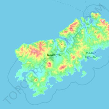
Name: Shikotan topographic map, elevation, terrain.
Average elevation: 31 m
Minimum elevation: -1 m
Maximum elevation: 411 m
Make a donation
Gear up for your next adventure:
As an Amazon Associate, this site earns from qualifying purchases at no extra cost to you.