Geolocate

Korčula topographic map

Interactive map

Click on the map to display elevation.

About this map

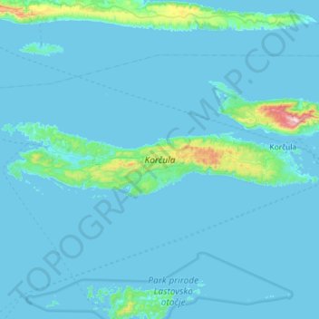
Name: Korčula topographic map, elevation, terrain.

Location: Korčula, Dubrovnik-Neretva County, Croatia (42.89342 16.62760 42.99415 17.20226)

Average elevation: 44 m

Minimum elevation: -1 m

Maximum elevation: 942 m

Other topographic maps

Click on a map to view its topography, its elevation and its terrain.

Dubrovnik

Croatia > Dubrovnik-Neretva County

Average elevation: 297 m

Nuga

Croatia > Dubrovnik-Neretva County > Borovci

Average elevation: 173 m

Podgradina

Croatia > Dubrovnik-Neretva County

Average elevation: 95 m

Pelješac

Croatia > Dubrovnik-Neretva County

Average elevation: 90 m

Prižba

Croatia > Dubrovnik-Neretva County

Average elevation: 88 m

Cavtat

Croatia > Dubrovnik-Neretva County

Average elevation: 49 m

Slano

Croatia > Dubrovnik-Neretva County

Average elevation: 245 m

Majkovi

Croatia > Dubrovnik-Neretva County

Average elevation: 415 m

Klek

Croatia > Dubrovnik-Neretva County

Average elevation: 131 m

Mljet

Croatia > Dubrovnik-Neretva County

Average elevation: 45 m

Čilipi

Croatia > Dubrovnik-Neretva County > Čilipi

Average elevation: 109 m

Šibenik

Croatia > Dubrovnik-Neretva County > Duba

Average elevation: 88 m

Dubrovnik

Croatia > Dubrovnik-Neretva County > Dubrovnik

Average elevation: 199 m