
Make a donation
Gear up for your next adventure:
As an Amazon Associate, this site earns from qualifying purchases at no extra cost to you.
Ampato topographic map
Click on the map to display elevation.
Make a donation
Gear up for your next adventure:
As an Amazon Associate, this site earns from qualifying purchases at no extra cost to you.
Ampato
El Ampato (del aimara jamp'atu, 'sapo') es un volcán inactivo localizado en la Cordillera de Ampato al sur del Perú, en el distrito de Lluta. Tiene una altitud de 6.290 m s. n. m. Cerca de la cumbre de este nevado fue descubierto un cadáver congelado en septiembre de 1995 por el arqueólogo de montaña Johan Reinhard y el andinista Miguel Zárate. A dicha momia femenina se le conoce como Juanita, la Dama de Ampato o la Dama de Hielo. Durante expediciones dirigidas por los arqueólogos José Antonio Chávez y Johan Reinhard en octubre de 1995 y diciembre de 1997 se encontraron a 5.850 m tres momias incaicas.
Make a donation
Gear up for your next adventure:
As an Amazon Associate, this site earns from qualifying purchases at no extra cost to you.
About this map
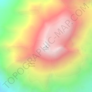
Name: Ampato topographic map, elevation, terrain.
Location: Ampato, Lluta, Caylloma, Arequipa, Perú (-15.82055 -71.88022 -15.82045 -71.88012)
Average elevation: 5,784 m
Minimum elevation: 5,085 m
Maximum elevation: 6,284 m
Make a donation
Gear up for your next adventure:
As an Amazon Associate, this site earns from qualifying purchases at no extra cost to you.
Other topographic maps
Click on a map to view its topography, its elevation and its terrain.