Geolocate

Austin topographic map

Click on the map to display elevation.

About this map

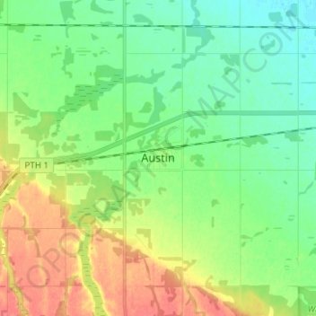
Name: Austin topographic map, elevation, terrain.

Location: Austin, Municipality of North Norfolk, Manitoba, Canada (49.90871 -98.97650 49.98871 -98.89650)

Average elevation: 314 m

Minimum elevation: 295 m

Maximum elevation: 346 m

Gear up for your next adventure:

🧗Locking Carabiners - Secure gear to your pack or for light technical use
🐕Dog Hiking Gear - Equipment for hiking safely with dogs
🧥Packable Down Jackets - Lightweight warmth that compresses small in your bag
🌄Outdoor Binoculars - Compact binoculars for landscape observation
🥾Walking Shoes - Lightweight walking shoes for countryside and coastal paths

As an Amazon Associate, this site earns from qualifying purchases at no extra cost to you.